Skip to content

Operational Tools, Uncompromising Science

Water Supply Forecasting

  • Research-grade hydrological modeling based on the Distributed Hydrology Soil Vegetation Model (DHSVM), developed by Wigmosta et al. (1994) and the Pacific Northwest National Laboratory
  • Exclusive automatic processing workflow sets up and calibrates DHSVM for any watershed in the West
  • Best-in-class remotely sensed snow data assimilation using the Snow Assimilation Water Accounting Method (SAWAM), matching observations while preserving the mass balance and model physics
  • Daily to seasonal water supply forecasts (WSF) available for any watershed in the West using historical ensemble meteorology data or subseasonal-to-seasonal (S2S) weather forecasts in the sole-source DHSVM Auto-WSF framework

Snow Surveys

  • Specializing in multi-day, high-elevation, backcountry snow surveys in remote mountains
  • Cooperating with Airborne Snow Observatories, Inc. (ASO) to constrain snow densities in snow water equivalent (SWE) maps using multi-day field surveys and machine learning in the Wind River Range
  • Deepest snowpit ever measured in Wyoming: 4.85 m / 15.9 ft. deep, 2.75 m / 9.0 ft. SWE

Decision Support

  • Multi-objective decision support tools provide concrete pathways to manage competing economic, cultural, and ecological water resource goals in response to forecasts
  • Pioneering the development of Forecast-Informed Agricultural Adaptation (FIAA) to optimize seasonal planting, irrigation, diversion, and recharge strategies at the irrigation district scale
  • Collaborating with the Wind River Water Resources Control Board to promote the 15 beneficial uses of water identified by the Wind River Water Code of the Eastern Shoshone Tribe and Northern Arapaho Tribe using Mountain Hydrology LLC water supply forecasts

Founder

Eli Boardman

  • NSF Graduate Research Fellow in Hydrology at the University of Nevada, Reno
  • B.A. cum laude Dartmouth College, Physics and Environmental Earth Sciences

Mission

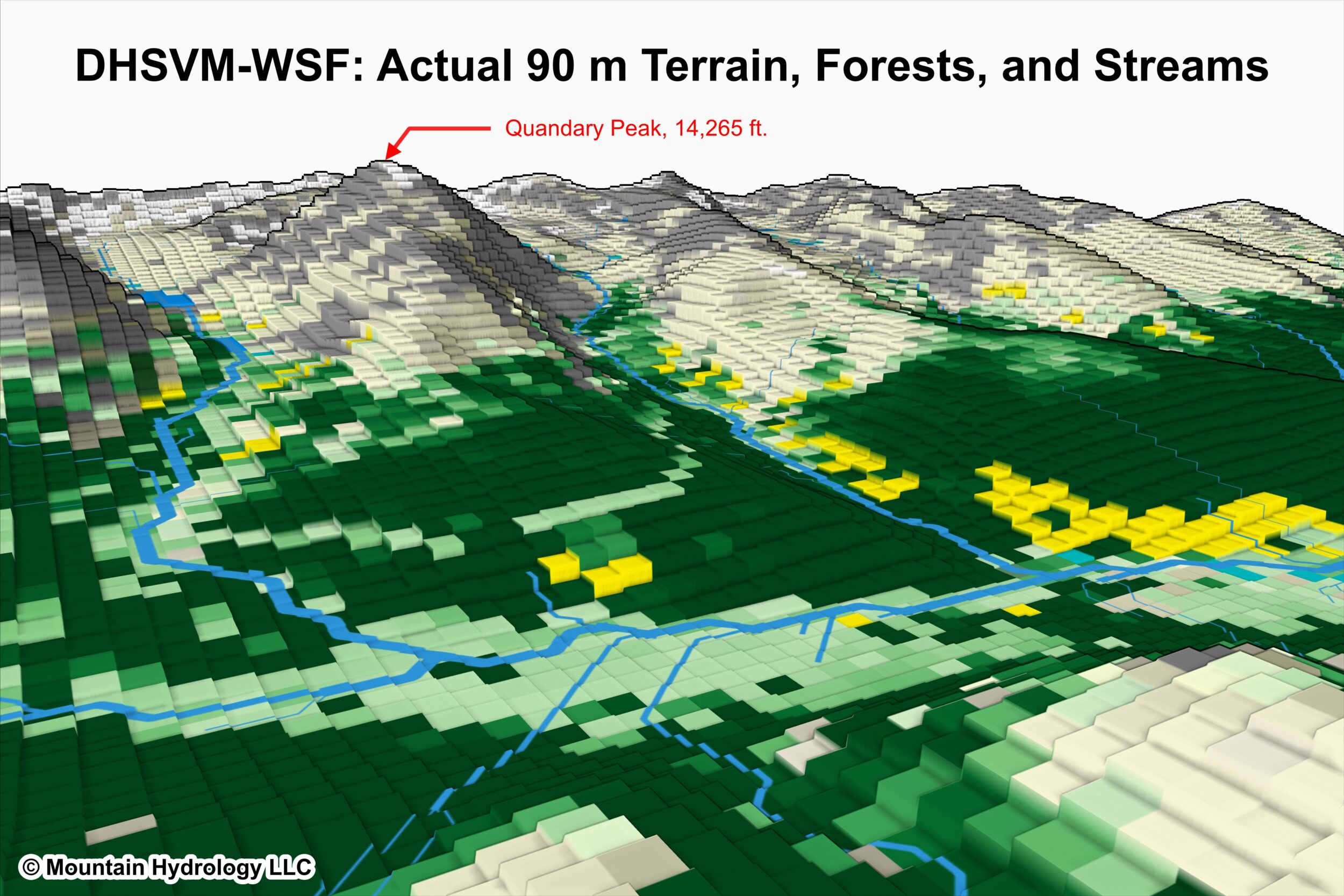
To advance the science of mountain hydrology with holistic research at the intersection of observation, modeling, and policy; to deliver operational tools leveraging the best-available science; and to promote the resilient and efficient use of Earth’s water resources.

Current Projects

  • Principal investigator of the Wind River Mountain Research Lab, dedicated to furthering the scientific understanding of cryospheric and hydrologic processes in the Wind River Range, Wyoming
  • Collaborating with the Wind River Water Resources Control Board, which represents the water interests of the Eastern Shoshone and Northern Arapaho Tribes on the Wind River Indian Reservation, to explore linkages between Tribal water rights and physical hydrology in a changing climate
  • Collaborating with ASO to map the Wind River Range glaciers using lidar across multiple ablation seasons
  • Collaborating with the University of Nevada, Reno, to model the interaction of wind, snow, and glaciers, and predict how climate change will disrupt historical streamflow patterns
  • Collaborating with the Office of the Tribal Water Engineer to quantify the heterogeneous vulnerability of irrigation districts to shifting cryospheric storage cycles and identify opportunities to increase agricultural resilience

Airborne Snow Surveys for Water Supply Forecasting in the Wind River Range, WY

  • Part of the Bureau of Reclamation’s Snow Water Supply Forecasting Program
  • News Release
  • Developing…check back soon!

Experimental Water Supply Forecasts in California

  • Real-time demonstration of the DHSVM Auto-WSF framework for select basins in water year 2024
  • Contact Eli Boardman for more information, or to request a forecast demonstration in your basin!

Deep Drift Snow Fieldwork

  • Conducting yearly snow surveys in the Wind River Range, Wyoming to measure the properties of deep snow drifts (>3 m), which are rarely sampled and poorly modeled
  • Preliminary results challenge the conventional understanding of processes driving snow densification in windy environments
  • Invented a new method to identify rating curve discrepancies using ASO SWE data and reservoir inflow records, leading to the revision of historical USGS data for a major stream gage [link]
  • Established and actively maintain 2 real-time stream gages in the Wind River Range, including acquiring winter low-flow data requiring extensive ice removal, rarely achieved for similar streams

A Nevada Limited Liability Corporation

All Rights Reserved. Copyright Eli Boardman.